
News
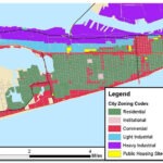
What Are Zoning Laws?
What Are Zoning Laws? ‘Zoning laws are critical’: Are you allowed to build an extension — or list your home ...

USGS National Map
The National Map is a suite of products and services that provide access to base geospatial information to describe the ...
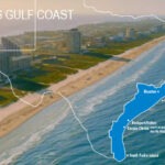
Travel Texas Guides
Texas Coast Travel Guides The over 350 miles of Texas Gulf Coast is protected by barrier islands stretching from Galveston ...
How Texas Beach Homes uses Longitude and Latitude
How Texas Beach Homes uses Longitude and Latitude We use cloud computing to geocode each property to determine its longitude and ...

GLO Texas Coast Master Plan
GLO Texas Coast Master Plan Covers 367-Miles A statewide plan to protect and promote a vibrant and resilient Texas coast ...

Galveston Port Bolivar Ferry
One of the two Texas Coast's Highway Ferry systems The Galveston-Port Bolivar ferry takes travelers between Galveston Island and the ...
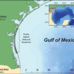
The History of Padre Island
The Longest Stretch of Undeveloped Barrier Island in the World Padre Island National Seashore separates the Gulf of Mexico from ...

Working With a Real Estate Agent in Texas
Working With a Real Estate Agent in Texas A good agent should be familiar with local market conditions and prices ...
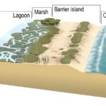
USGS What is a barrier island?
USGS What is a barrier island? The United States Geological Survey (USGS), formerly simply known as the Geological Survey, is ...