
How Texas Beach Homes uses Longitude and Latitude
We use cloud computing to geocode each property to determine its longitude and latitude to leverage our experience and expertise for you through automation with advanced technology and spatial polygons that accurately define distinct views, parts of town, and lifestyle areas used by local community leaders, and our website users for improved property search and market analysis.
In the past, it’s been difficult to get accurate information relevant to the unique parts of town and lifestyles in our Texas coastal resort areas, because reported sales information is lumped together for every type of property in the entire city, and relevant search information is often restricted by over reaching restrictions.
This often makes analysis over time, and comparisons between markets, irrelevant, and thus more difficult to spot better opportunities and deals, especially if you look at real estate as an investment.
- The unique parts of town on our islands have significant differences in lifestyle and price points, even just between the center of the island and beachfront/bayfront, and that’s walking distance!
- We’ve created coastal standards so you can compare properties, demand and market statistics by property types, parts of town, views, and lifestyles between Texas‘ resort markets areas.
It took us years to develop this technology and we leverage powerful cloud computing resources to process the MLS active listings and sales for the entire Texas coast every night to offer you valuable insights that can help you make smarter purchase decisions!
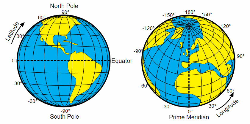
What is longitude?
Longitude measures distance east or west of the prime meridian, or lines that are north (up) and south (down).
Lines of longitude, also called meridians, are imaginary lines that divide the Earth. They run north to south from pole to pole, but they measure the distance east or west.
- The prime meridian, which runs through Greenwich, England, has a longitude of 0 degrees. It divides the Earth into the eastern and western hemispheres. The antimeridian is on the opposite side of the Earth, at 180 degrees longitude. Though the antimeridian is the basis for the international date line.
- Longitude is measured in degrees, minutes, and seconds. Although latitude lines are always equally spaced, longitude lines are furthest from each other at the equator and meet at the poles.
- Navigators and mariners have been able to measure latitude with basic tools for thousands of years. Longitude, however, required more advanced tools and calculations. The best and simplest way to measure longitude from a ship was with an accurate clock.
Accurate clocks determine longitude and are found in GPS satellites and stations. Each GPS satellite is equipped with one or more atomic clocks that provide precise time measurements. The satellites broadcast radio signals with precise timestamps. The GPS position on a smartphone is accurate to within about 5 meters (16 feet), but processed CORS data can provide longitude that’s accurate to within a few centimeters.
What is latitude?
Latitude measures the distance north or south of the equator, or lines that are around, like the equator.
Lines of latitude, also called parallels, are imaginary lines that divide the Earth. They run east to west but measure your distance north or south. The equator is the most well-known parallel. At 0 degrees latitude, it equally divides the Earth into the Northern and Southern hemispheres. From the equator, latitude increases as you travel north or south, reaching 90 degrees at each pole.
- There are other named lines of latitude. They’re based on the sun’s position during Earth’s orbit, and they help us understand climate, weather, and ocean currents.
- The Tropic of Cancer, at 23 degrees north, and the Tropic of Capricorn, at 23 degrees south, are the boundaries of what we consider the tropics. The Arctic Circle and the Antarctic Circle are 66 degrees north and south, respectively. They mark the boundaries of the Arctic and Antarctic regions.
- Each degree of latitude covers about 111 kilometers on the Earth’s surface. One degree of latitude can be further divided into 60 minutes, and one minute can be further divided into 60 seconds. Unlike longitude lines, which get closer to each other at the poles, latitude lines are parallel.
- No matter where you are on Earth, latitude lines are the same distance apart.
Degrees of Accuracy
If we assume the Earth is a perfect sphere, lines of latitude are simple to calculate. The latitude of a certain point on the surface of the Earth is the angle between two lines: a line from that location to the center of the Earth and a line from the center of the Earth to the Equator. This method of calculation gives us geocentric lines of latitude.
However, this method is not accurate enough for astronomy, global positioning, and other real-world applications. Instead, we use what is known as geodetic latitude. This method of calculating latitude for any point on Earth accounts for the fact that the Earth is squished at the poles due to the centrifugal force created by the planet’s rotation. Measuring latitude lines with high degrees of accuracy is but one component of geodesy, the science of accurately measuring and understanding the Earth’s geometric shape, orientation in space, and gravity field.